~ 720th Military Police Battalion Reunion Association Vietnam History Project ~ |
|
|
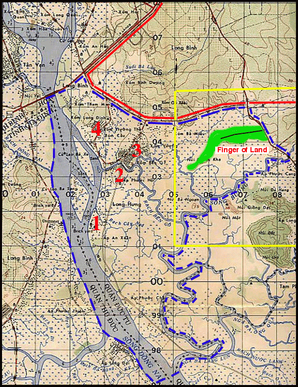
Approximate boundary of the 615th MP Company Area of Operations (AO), in the eastern portion of the 720th MP Battalion Tactical Area Of Responsibility (TAOR), III Corps Tactical Zone, Bien Hoa Provence, Vietnam in October of 1967. The area outlined in yellow was the approximate boundary of the 615th MP Company AO for their Ambush and Reconnaissance activities from 20 October 1967 to early January 1968. When the Battalion organic companies asssumed responsibility for the AO, the boundary was then restricted to the area within the blue lines. The area outside on the right was under operational control of the Army of the Republic of South Vietnam (ARVN) and 9th Infantry Division until mid-1968, followed by the Royal Volunteer Regiment of the Thai Army. The area in green was the Finger of Land, the black line running through its center represents the dirt roadway/trail along the top of the ridge. It connected to Highway QL-15 to the right. The area outlined in blue is the boundary of the 720th MP Battalion TAOR that would exist from 20 October 1967 until September 1970 when Operation STABILIZE was ended. The area outlined in red was the approximate boundaries of Long Binh Military Post. The TAOR bordered the southern boundary of the post. The primary four villages (hamlets) within the TAOR are numbered in red: 1- An Xuan; 2-Long Hung; 3-An Hoa Hung; 4-Long Binh Tahn. Map Edited by the History Project Manager with assistance of SP/4 Lynn "Jorgie" Jorgensen, 615th MP Company. |
Use Your Browser Button To Return |