~ 720th Military Police Battalion Reunion Association Vietnam History Project ~
The Old French Fort Watchtower
Last Updated ~ 3 January 2012
   Regardless of MOS if you recognize or participated in any of the events listed on this page and would like to contribute any information, personal stories, documents, media articles, photographs or comments, please take a moment to contact the History Project Manager at the Email Link provided for you above. Your contributions are important to the recording of the Battalion history and always welcomed here.
   Please take the time to report any broken links on this page to the Webmaster via the above Email Link.
    Send your photographs as .jpg via the Email Link at the top of this page. Scan them as large as you can, one to an Email and include as much information as you can. Direct any questions via the Email Link.
18th MP
Brigade
89th MP
Group
720th MP
Battalion
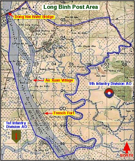
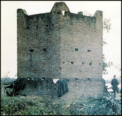
   The structure called the French Fort was an old watchtower used by the French Army and local Vietnamese auxiliary forces during the First Indochina War also known as the French Vietnamese War (1946-1954). At the time of its use the tower was one of several located along an old roadway that followed the Dong Nai River (western border) of the 720th MP Battalion Tactical Area Of Responsibility (TAOR).

   The French Union Forces built "poste kilométrique," (watch towers) as one of their key features of the pacification strategy.

French Fort - Click to enlarge

    The isolated watch towers were manned by a handful of local auxiliaries and dotted every kilometer along the lines of communications. At that time radio communication among the small village outpost was non existent.

  The outpost's were arranged in close proximity to afford the militia manning them to communicate between themselves by runners or signals.

   The roadway depicted in the map no longer existed when the Battalion took over operation of the TAOR on 11 September 1967 under Operation STABILIZE.

   The areas within the TAOR outside of the village limits was classified as a "Free Fire Zone" after darkness. During Operation Stabilize, 11 September 1967 through 25 July 1970, the tower was never staffed, however, it was often used by Battalion Ambush and Recon squads working in the area.

1967
1967
1967
1967
1967
1967
1968
   The tower was identified as "FF," and used as a checkpoint and landmark on all organic operational maps. Because of its close proximity to the Dong Nai River it was use by the local Viet Cong as a staging area for river traffic ambushes. Local helicopter units started using it for target practice. By the time Operation Stabilize ended the tower was reduced to a pile of rubble.
Use Your Browser Button To Return